
| Icelandic Meteorological Office
Dept. of Geophysics |
Map of the soutwest part of Iceland
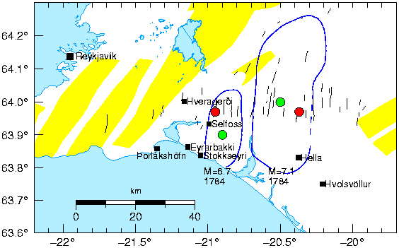
Figure 2:
Map of the southwestern part of Iceland.
Thin black lines denote mapped
faults
( Einarsson and Eiríksson 1982; Einarsson and Sćmundsson 198
7;
Erlendsson and Einarsson 1996).
The red dots show estimated epicenters of the MS=7.1 and MS=6.7,
1784 earthquakes, that we use in our study, based on mapped surface faults
(P. Einarsson, personal communication, 1999).
The green dots show estimated epicenters of the two earthquakes
based on areas of destruction Stefansson/etal:1993.
The regions in which over half of the buildings were destroyed in the
earthquakes are shown with
N-S elliptical regions drawn in blue ( Björnsson 1978).
Corresponding intensity is MM VIII-IX ( Einarsson et al. 1981).
The black squares show current locations of towns and major villages.