NEA report in a Word document (report2001.doc).
Intsallation and operation of the SMSITES seismic stations BRE, FLA and HED as well as the SMSITES hydrological network was described in the June 2001 SMSITES monthly report. Basic information about location of the monitoring stations is found in the first year SMSITES report. This report will describe more generally the conditions of the stations as well as the data retrieved and basic evaluations.
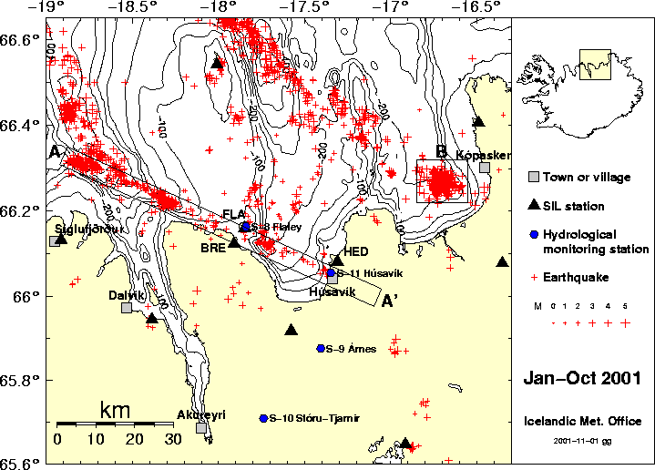
Figure 1: The map shows erathquake epicenters (red crosses) during January-October 2001. SIL seismic stations are shown with black triangles and hydrological monitoring stations are shown with blue circles. The box AA' represents here the Husavik-Flatey fault. The box AA' is 90 km long and 5 km in width. Earhquake swarm in Oxarfjordur is shown within the box B.
Location and uptimes of the stations BRE, FLA and HED is shown in table 1, table 2 and figure 2..
It is to be noted that there is instrumental noise on the Z and the E components of the FLA records, which will affect small seismic signals on these components for frequencies above 1Hz. The reason for this is malfunction in the digitizer which will be changed out as soon as another digitizer can be made available.
| Station | Latitude | Longitude | Elevation | Name |
| BRE | 66.12338° | -17.90967° | 56 m | Brettingsstaðir |
| FLA | 66.16067° | -17.84750° | 25 m | Flatey |
| HED | 66.08100° | -17.31000° | 80 m | Héðinshöfði |
| Station | Jan | Feb | Mar | Apr | May | Jun | Jul | Aug | Sep | Oct | Jan-Oct |
| BRE | 6.78% | 86.19% | 94.87% | 99.78% | 99.63% | 99.44% | 99.96% | 100.00% | 99.95% | 99.11% | 88.48% |
| FLA | 6.80% | 62.60% | 52.53% | 91.05% | 98.68% | 92.96% | 99.93% | 97.34% | 100.00% | 95.93% | 79.80% |
| HED | 99.30% | 90.11% | 100.00% | 99.84% | 95.37% | 95.09% | 95.74% | 96.31% | 95.28% | 89.02% | 95.65% |

Figure 2: Uptimes/Downtimes for the SIL stations BRE, FLA and HED during January-October 2001. Uptimes are in green and downtimes in red.
The strip AA' shown in figure 1 represents the Husavik-Flatey fault used here in this report. The box AA' from NW to SE is 90 km long and 5 km in width.
The seismicity is described in figure 1 and figures 3-6. The seismic rate is constant and at conventional sites except for a swarm in September 2001, 5-15 km north of Siglufjordur (close to A). As seen in figure 6 the activity concentrates on three swarm localities with some tendency to be distributed perpendicular to the direction of the main fault.
In localizing earthquakes including the FLA station we have observed that FLA has frequently a positive residual, i.e. late arrivals of P and S, which for near sources is almost a second for the Ps. We think this is related to low velocity inside the fault and especially in sediments which are especially thick at the top of the fault. We tested this however by recording by independent equipment at the same site, to make sure that this is not an instrumental problem, confirming that we observing a structural anomaly.
Using local earthquakes to study the tomography of the area around the Húsavík-Flatey fault has started in cooperation between IMO and Uppsala. The first step is to relocate earthquakes by crosscorrelation of similar seismic phases, thus increasing the relative location to possibly 5-10 meters accuracy and also enhanching the absolute accuracy. Ari Tryggvason is working on the tomography project in Uppsala and it is reported in more detail by Uppsala (Reynir Böðvarsson). For this purpose Ari will apply procedures which he has developed and is now adapting to be used in the Húsavík-Flatey area.
Work towards mapping of active faults, fault movements and stresses based on microearthquakes within has started This is based on manual processing of the automatic evaluation of the SIL system which is ongoing. Relative locations by available SIL procedures and successive fault mapping by applying also information from refined fault plane solutions will start in November 2001. This work will be carried out in Iceland, but in cooperation with Uppsala. The relocations will be intervened with relocations which are necessary for the tomography work.
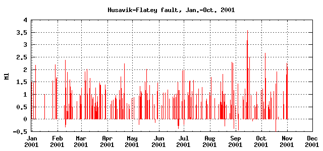
Figure 3: Magnitude versus time
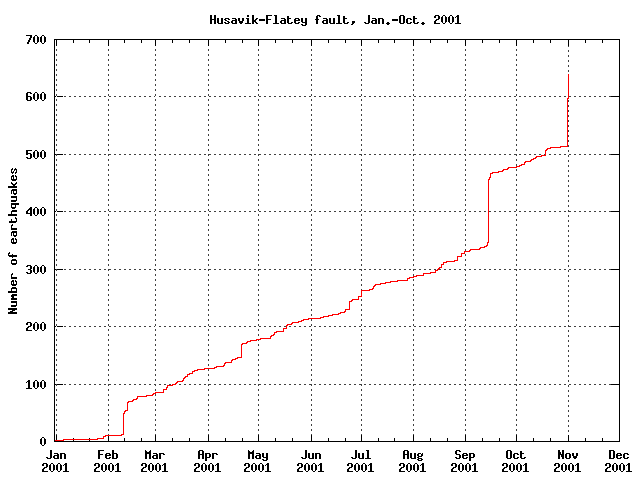
Figure 4: Cumulative number of earthquakes versus time.
0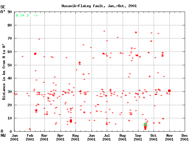
Figure 5: Earthquakes along the Husavik-Flatey fault versus time.
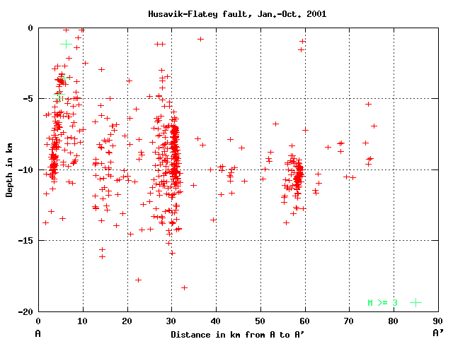
Figure 6: Earthquakes depths versus distance along AA' i.e. along the Husavik-Flatey fault.
A swarm started in this area soon after mid September as seen in figure 1 and figures 7-11. The activity was located at various depths within an area of around 2 km diameter to start with, but with main center of activity moving 2-3 towards SW at a later stage. A work is starting to analyse this swarm in detail, based on refined relative locations as well as comparison with earlier swarms in this area. This spot has frequently shown swarm activity, but the present activity is the most intense since 1994, i.e. since detailed and accurate enough information became awailable to draw such a conclusion.
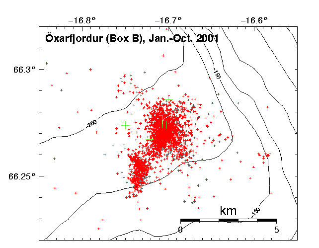
Figure 7: The crosses represent earthquakes in Öxarfjördur during January-October 2001. See Figure 1 box B. The green crosses are earthquakes with magnitude greater than or equal to 3 and the red ones are less than 3 in magnitude.
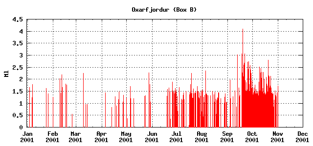
Figure 8: Magnitude versus time.
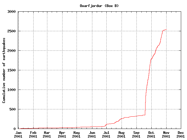
Figure 9: Cumulative number of earthquakes versus time..
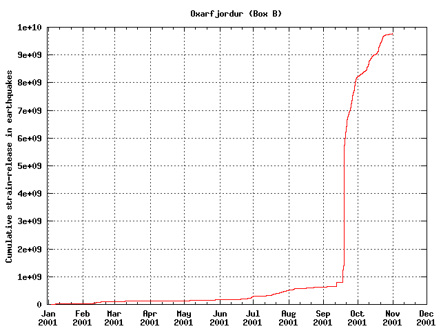
Figure 10: Cumulative strain-release during Jan.-Oct. 2001 in Oxarfjordur (box B).
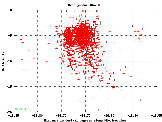
Figure 11: Earthquake depths distribution along WE-direction.