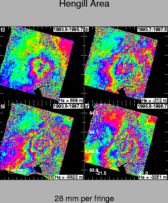
The Hengill triple junction, at the western end of the Southern Iceland
seismic zone (SISZ), exhibits the highest level of continuous seismicity in
Iceland. In July 1994, an unusually persistent swarm of earthquakes, with
magnitude less than 4, continued through 1995 with intermittent activity
through 1999. This seismicity appears to be mechanically coupled to the
ongoing volcanic activity. To study this coupling, we measure crustal
deformation using interferometric analysis of synthetic aperture radar
(INSAR) images acquired by the Earth Resources Satellites ERS-1 and ERS-2
of the European Space Agency. This technique provides dense (![]() 100 pixels/km2)
spatial coverage and monthly sampling in the summer months between
1993 and 1998. The resulting interference patterns show clear fringes, even
after four years, on the barren ground cover near the Hengill central
volcano. The radar coherence breaks down, however, in less than a month in
the coastal lowlands containing most of the active faults of the SISZ. The
principal signal in the interferograms is a concentric pattern with radius
of approximately 10 km, centered on Hrómundartindur volcano. These fringes
indicate a relative shortening of the radar line-of-sight distance (range)
of approximately 1.5 cm/year. We intepret this signature as mostly vertical
uplift due to increasing pressure in a magma chamber at depth. To explain
it, we employ a simple "Mogi" model of a point source in an elastic half
space. After estimating the four parameters of this model for each of the
10 observed interferograms, we find that the rate of uplift is constant,
with an average value of 19
100 pixels/km2)
spatial coverage and monthly sampling in the summer months between
1993 and 1998. The resulting interference patterns show clear fringes, even
after four years, on the barren ground cover near the Hengill central
volcano. The radar coherence breaks down, however, in less than a month in
the coastal lowlands containing most of the active faults of the SISZ. The
principal signal in the interferograms is a concentric pattern with radius
of approximately 10 km, centered on Hrómundartindur volcano. These fringes
indicate a relative shortening of the radar line-of-sight distance (range)
of approximately 1.5 cm/year. We intepret this signature as mostly vertical
uplift due to increasing pressure in a magma chamber at depth. To explain
it, we employ a simple "Mogi" model of a point source in an elastic half
space. After estimating the four parameters of this model for each of the
10 observed interferograms, we find that the rate of uplift is constant,
with an average value of 19![]() 2 mm/year from 1993 through 1998. The best
fitting models locate the point source at a depth of 7
2 mm/year from 1993 through 1998. The best
fitting models locate the point source at a depth of 7![]() 2 km depth at
64.032/circN and 21.213/circW. The
constant rate of volcanic deformation contrasts markedly with the episodic
moment release by swarms or "crises" of earthquakes. To explain this contrast,
we propose that the ongoing volcanic activity increases the stress
in the brittle country rock. When the stress reaches the Coulomb failure
threshold, the rock breaks, rupturing a fault and releasing the stress (Figure 14).
2 km depth at
64.032/circN and 21.213/circW. The
constant rate of volcanic deformation contrasts markedly with the episodic
moment release by swarms or "crises" of earthquakes. To explain this contrast,
we propose that the ongoing volcanic activity increases the stress
in the brittle country rock. When the stress reaches the Coulomb failure
threshold, the rock breaks, rupturing a fault and releasing the stress (Figure 14).
 |