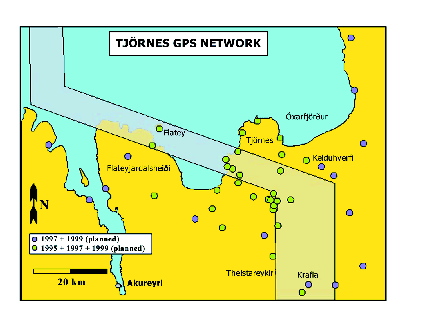
The Tjörnes GPS Network (TGN, Figure 17) established by T. Villemin consists of about 45 sites distributed in the northern Iceland seismic zone.
It completes the geodetic networks already installed over the whole Iceland at a smaller scale. The TGN has been designed to measure the surface displacement field on each side of the Húsavík-Flatey fault (HFF). It has been done in order to estimate if there are locked fault segments in the area and who these segments can contribute to increase the seismic risk. 32 points have been measured both in 1995 and 1997.
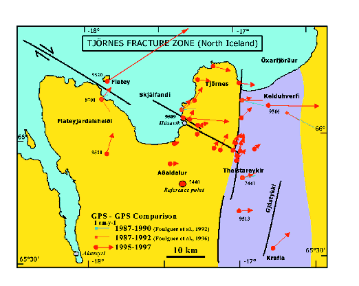
The 1995-1997 velocities (Figure 18) have been computed by reference to a point located in the southern part of the network. All vectors are significant at a 95% confidence level. Two tendencies can be distinguished on the Tjörnes peninsula: eastward velocities reaching 13 mm/year for the most northern points of the peninsula and NNE velocities up to 15 mm/year for the points located on both sides of the HFF. Displacements to the east have been computed for the points located in the fissure swarms. Points on Flateyjardalur move to the north. The point on the Flatey island reveals a large displacement to the NE that could be due to a local instability. The assumption of an interseismic strain has been tested by using a simple dislocation model. This model assumes that a set of buried planar fault surfaces are locked above a given depth and affected by uniform aseismic creep below this depth. In order to determine this brittle/ductile transition we used the microseismicity recorded by the SIL network from 1995 to 1997. We assume that most earthquakes are localized in the brittle crust. Thus gives us a limit at a 10 km depth in average. We founded a solution that minimizes the differences between simulated and observed velocities.
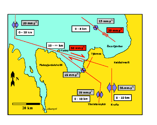
The model
(Figure 19)
assumes: (1) a dyke opening of 20 mm/year affecting all the brittle crust along the Kolbeinsey ridge; (2) two dyke openings of 30 mm/year and 20 mm/year respectively along the Krafla and Þeistareykir fissure swarms; (3) a dextral strike slip fault striking N100![]() E between the two previous rift segments with a velocity of 50 mm/year below a depth of 10 km and completely locked above the brittle/ductile transition; (4) a 15 mm/year opening zone striking N140
E between the two previous rift segments with a velocity of 50 mm/year below a depth of 10 km and completely locked above the brittle/ductile transition; (4) a 15 mm/year opening zone striking N140![]() E south of the HFF; (5) a fault along the Grímsey lineament with both a 15 mm/year opening and 20 mm/year dextral strike-slip movements. In addition small wavelength tendencies has been adjusted by superficial faults.
This model based on our 1995-1997 TGN comparison revealed extension and strike slip movements 3 to 4 times larger than the average velocity. The transform motion is locked on a large (150x10 km) fault surface and this represents the main risk for destructive earthquakes in the near future. From a mechanical point of view, the lockage could be due to the increase of normal stress on this surface following the double opening north and south of the fault zone.
E south of the HFF; (5) a fault along the Grímsey lineament with both a 15 mm/year opening and 20 mm/year dextral strike-slip movements. In addition small wavelength tendencies has been adjusted by superficial faults.
This model based on our 1995-1997 TGN comparison revealed extension and strike slip movements 3 to 4 times larger than the average velocity. The transform motion is locked on a large (150x10 km) fault surface and this represents the main risk for destructive earthquakes in the near future. From a mechanical point of view, the lockage could be due to the increase of normal stress on this surface following the double opening north and south of the fault zone.