The M=5.1 earthquake June 4, 1998, on Hellisheiði, in the Hengill area provided excellent geodetic and seismic data for modelling of near-field displacements in the largest earthquake in the area since 1955.
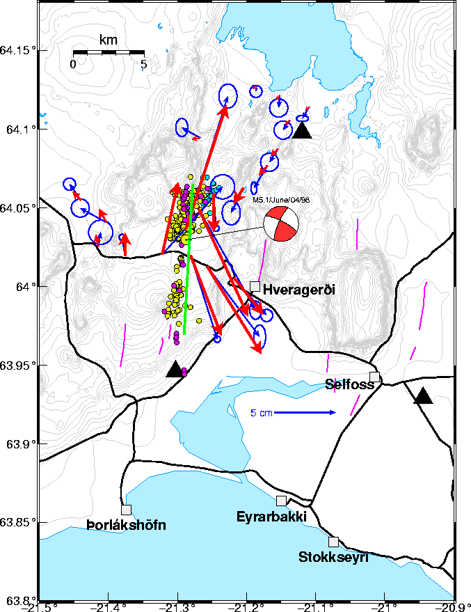
A large earthquake swarm started in the Hengill area on June 3, 1998, and culminated with a M=5.1 earthquake on June 4, 1998, at 21:37 GMT, followed by thousands of aftershocks. Geodetic measurements were being done by the National Energy Authority at the time of the earthquake and repeated measurements begun on June 5, 1998. The data were processed by Sigrún Hreinsdóttir at the Science Institute and NVI, using the IGS station in Reykjavík as a reference station, and CODE orbits. That provided the surface displacements in the ITRF96 reference frame.
The surface displacements have been used by Þóra Árnadóttir at IMOR.DG to construct a dislocation model for the earthquake. The dislocation model is a rectangular fault with uniform slip model in an elastic half-space. The best fit model found by nonlinear optimization algorithm, is a vertical N-S fault with 30 cm right-lateral strike slip motion and 15 cm dip-slip motion, down to west. The fault is about 11 km long, and extends from the surface down to about 2 km depth. The location of the fault model fits well with the location and focal mechanism of the main shock and locations of aftershocks, although these are not used to constrain the model. The model fits about 96% of the data signal (Figure 3).
The main shock ruptured a N-S structure, and could
therefore be similar to historical events that have
occurred in the South Iceland seismic zone, where
a M=7 event is currently anticipated. As there is
no instrumental data for the large historical
events it is important to study these recent
earthquakes, to better understand the mechanism
of the larger events.
Preparations are ongoing for modelling near-field ground motions expected in large South Iceland seismic zone earthquakes on basis of the result of the modelling above, on basis of strong motion records and records of the SIL network for the earthquake of June 4, described above, and on basis of historical documentation of near-field destruction in historical South Iceland seismic zone earthquakes.