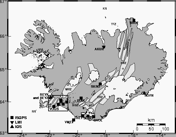
Iceland is situated on the divergent mid-Atlantic ocean ridge and owes its existence to the Icelandic hotspot, centered beneath Vatnajökull ice cap (Figure 1). The mid-Atlantic plate boundary comes onshore on the Reykjanes peninsula in South Iceland and continues east along the peninsula towards the Hengill triple junction area. At Hengill the plate boundary goes NNE along the Western volcanic zone and towards east along the South Iceland seismic zone (SISZ), which is a transform zone. The SISZ merges with a propagating rift zone, the Eastern volcanic zone, which continues north through the country to the Kolbeinsey ridge via the Tjörnes fracture zone. The rifting of 1.96 cm/yr across Iceland [ DeMets et al (1994)] is accommodated by the eastern and western volcanic zones. Presently the rifting is mostly (85%) taken up by the Eastern volcanic zone and the spreading of the Western volcanic zone seems less active as has been shown with episodic GPS network measurements [ Sigmundsson et al (1995)].
The interaction between the divergent plate boundary and the mantle plume results in various phenomena. Eruptions are frequent and seismic events can exceed magnitude 7 in the transform zones in the south and the north. A number of episodic GPS measurements have been made in Iceland to study deformation associated with volcanism and earthquakes, the first campaign being performed in 1986 [ Foulger et al (1986)]. Until now the emphasis has been on episodic network measurements allowing good spatial coverage but poor resolution of temporal variations in deformation fields. Temporal variations in crustal deformation rates have been observed in numerous geodetic studies in Iceland (e.g. Tryggvason (1986),Tryggvason (2000), Hreinsdóttir (1999), Jónsson et al. (1997), Sigmundsson et al. (1995), Sturkell et al. (2002a), Sturkell et al. (2002a)). Continuous GPS stations give good temporal resolution and are thus well suited to study the temporal variations in deformation in Iceland. The stations also serve well for timing deformation events and offer the opportunity to monitor the state of the crust in near real-time.
Presently there are a few thousand permanent GPS stations operating in the world.
The largest networks are in Japan and North America, with over 1200
stations each. Permanent GPS stations are used for a great variety of applications,
e.g. to observe plate movements (e.g. Sella et al. (2002)), constrain
earth orientation parameters, serve as base stations for mapping purposes and navigation,
monitor deformation related to earthquakes and volcanoes (e.g. Owen et al. (2000),
Newman et al. (2001) and Lowry et al. (2001)),
observe deformation resulting from deglaciation (e.g. Scherneck et al. (2001)),
estimate oceanic and atmospheric loading
 |
This thesis concentrates on results from the permanently recording GPS stations in Iceland to study the plate movements and temporal variations of deformation fields associated with significant tectonic events such as the SISZ June 2000 earthquakes and volcanic events at Hekla and Katla.
 |