In this section the history of continuous GPS measurements in Iceland and technical aspects of the operating stations are discussed. Figures 1 and 2 show where the stations are located. Tables 1, 2 and 3 summarize the main characteristics of the stations. Further technical information and photos from many of the stations are available at the ISGPS website: http://hraun.vedur.is/ja/gps.html.
The instruments used at permanent GPS sites are quite different from the handheld instruments used for navigation by many people today. The instruments are of the same type as those used in geodetic network GPS measurements and utilize both carrier waves (L1 and L2) from the GPS satellites along with the codes modulated on to the carrier waves. Using these instruments along with long (4-24 hours) observation periods and advanced processing methods, relative position of geodetic stations can be achieved with subcentimeter accuracy. The GPS system and how subcentimeter positioning accuracy can be achieved is not described in this paper. Interested readers are referred to e.g. [Leick (1990)], [Dixon (1991)], [Sigmundsson (1992)], [Hugentobler et al. (2001)], [Hreinsdóttir (1999)] and [Jónsson (1996)].
Continuous GPS measurements in Iceland started when a station was installed by Bundesamt für Kartographie und Geodäsie (BKG) in Reykjavík (REYK) in November 1995. The station is operated in cooperation with the National Land Survey of Iceland (Landmælingar Íslands, LMI). REYK is still in operation and is a part of the International GPS Service (IGS) tracking network and used by many international data processing centers in their calculations, e.g. to determine the orbits of the GPS satellites. REYK is used as the reference station in processing of data from the ISGPS network. REYK is on the top of a three story concrete building, constructed in the 1970's, at the University of Iceland. The choke ring antenna is mounted on a tribrach on the rim of the elevator shaft which runs through the building and the receiver is inside the building. There is no radome mounted on the antenna. Data are collected continually to a Windows based PC computer and are transferred via an internet connection to BKG's data center on an hourly basis.
In May 1997 the second station, HOFN, was installed at Höfn, Hornafjörður, by
BKG and LMI. HOFN is on the top of a one story concrete building,
otherwise the setup and data aquisition are
similar to the one at REYK. The station
was equipped with a Trimble groundplane antenna with a radome until
September 21, 2001, when a Trimble choke ring antenna without a
radome was installed (Table 2). This caused a significant offset
in the time series (Section 4.1).
BKG installed the third station, REYZ, a few meters from REYK in September
1998. REYZ tracks not only signals from NAVSTAR GPS satellites,
but also from GLONASS satellites. GLONASS is the Russian
counterpart of the American NAVSTAR GPS system. Presently there
are 7 GLONASS satellites in operation. REYZ is equipped with Ashtech
instruments and the antenna has a conically shaped radome from Ashtech.
Intensive seismicity in the Hengill area, associated with uplift at
a rate of 2 cm/yr,
started in 1994
[Rögnvaldsson et al. (1998a)],
[Sigmundsson et al. (1997)],
[ Feigl et al. (2000)].
In 1998 the activity caused public concern and the initiation
of the ISGPS network.
The ISGPS network is a cooperation
project between the Icelandic Meteorological Office (IMO), Nordic Volcanological Institute (NORDVULK), Science Institute,
University of Iceland (SIUI), and University of Savoie (LGCA), France.
Funding to purchase four GPS instruments to use
for continuous measurements was obtained from the Icelandic Government and
the Reykjavík Energy corporation.
The main goal when designing the technical aspects of the ISGPS system was to
maximize monument stability and operational security and minimize the installation
and operational costs. It was originally planned to colocate the ISGPS stations
with stations in the SIL seismic network
[Stefánsson et al. (1993)],
[Böðvarsson et al. (1996)]
to lower the operational costs. However, it was considered more important to be close
to active deformation areas and to have solid bedrock for the ISGPS monument.
| |||||||||||||||||||||||||||||||||||||||||||||||||||||||||||||||||||||||||||||||||||||||||||||||||||||||||||||||||||||||||||||||||||||||||||||||||||||||||||||||||||||||||||||||||||||||||||||||||||||||||||||||||||||||||||||||||||||||
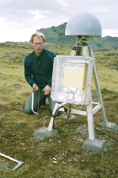
Figure 3 shows a photo of a typical setup for the ISGPS
stations.
The actual physical point being measured at the stations is a classic
geodetic copper benchmark cemented into solid bedrock or a concrete platform.
The antenna is screwed on top on of an approximately 1 m high stainless steel quadripod,
which is mounted directly over the benchmark
(Figure 3). The quadripod structure is made by a local machine shop
and is very stable on short and long timescales
due to the endurance and thermal expansion properties of stainless steel.
The thermal expansion factor for stainless steel is nominally a factor
of 10 smaller than for concrete.
The quadripod is fastened to the bedrock using two continuously threaded rods, 12 mm in
diameter, for each leg (Figure 3).
The rods are cemented in 11 to 22 cm deep holes, depending on bedrock type, using
chemical anchor capsules (Spit Maxima M12). This method is
for example used to secure large engine complexes.
The top plate of the quadripod is levelled by adjusting the position
of the legs on the threaded rods.
The quadripod structure is only 1 m high thus inducing more
multipathing into the measurements than a higher structure would do
[Hugentobler et al. (2001)]. To minimize
the effect of multipathing, choke ring antennas are deployed at all the ISGPS stations.
To prevent snow and ice accumulation on the antennas they all have hemispherical
plastic radomes from SCIGN (Southern California Integrated GPS Network)
[SCIGN (2001)].
Although this precaution is
taken, snow and especially rime have been observed to accumulate on the radome in
certain weather conditions. The stations are attended to at least once per year
to check if everything is working properly and to remeasure the antenna height.
| ||||||||||||||||||||||||||||||||||||||||||||||||||||||||||||||||||||||||||||||||||||||||||||||||||||||||||||||||||||||||
 |
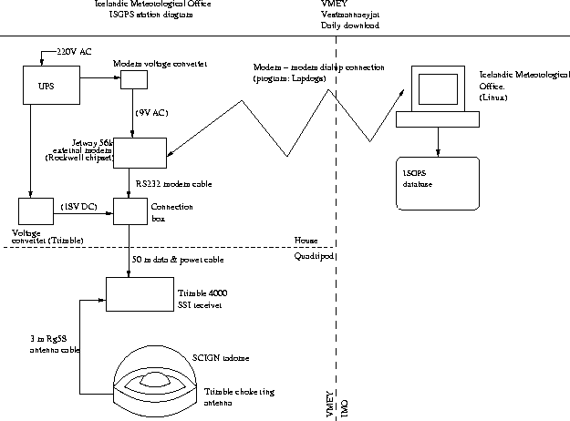 |
The data at all ISGPS sites are collected to the internal memory of the receivers in 24 hour long files, starting at midnight GMT. The receivers are set to log signals from the GPS satellites at 15 second intervals. The data files are downloaded automatically on a daily basis via a modem-modem connection during night hours (Figure 4). The communication rate is fixed at 9600 baud for all stations. The data files are 0.7 Mb to 1.6 Mb in size, depending on the internal receiver data format and elevation mask. Data from the Trimble receivers (Table 2) are downloaded using UNAVCO's (University NAVSTAR Consortium) download software, LAPDOGS [UNAVCO (2001b)]. Data from the Ashtech receivers (Table 2) are downloaded using Ashtech's remote33 software [Ashtech (2001)]. Both remote33 and LAPDOGS are based on Perl scripts which call communication routines that are specific for each receiver type. Data from REYK, HOFN and AKUR are acquired automatically on a daily basis via the ftp site of the National Land Survey of Iceland (LMI), ftp.lmi.is. The only electric equipment in the field are the receiver, antenna, modem and backup power (Figure 4). By avoiding to have a PC computer operating at each site the operational security is maximized and the number of objects that can break down in the field is minimized.
The first ISGPS station was installed at Vogsósar (VOGS) on March 18, 1999 (Table 1). VOGS is in a Holocene pahoehoe lava field. The station is colocated with a SIL station (vos) [Böðvarsson et al. (1996)], [Stefánsson et al. (1993)]. The station is 12 m from the seismometer vault. The receiver is in the vault and uses power from the same source as the seismological instruments. The power consumption for the Trimble 4700 is approximately 5 W. Data and power are transmitted over an approximately 1200 m long ground cable. This cable length is too long for the RS-232 communication standard to work, so RS-232/422 converters are deployed at both ends of the cable. The power for the instruments is transmitted at 70 V DC over the cable and is converted to 15 V in the vault. This is a standard in the SIL system. However, the receiver at VOGS (a Trimble 4700) does not turn itself on after a power failure unless the input power is over 18 V. Thus a DC/DC converter is used to run the receiver on 24 V. The daily data files are downloaded to a Linux computer, that also operates the seismic instruments, using LAPDOGS. The data are subsequently sent to the data center in Reykjavík via a X.25 link [Böðvarsson et al. (1996)]. The LAPDOGS software did not support communications with Trimble 4700 receivers until in late 2000. Until then the data were continually logged to a Windows computer using the Universal Reference Station (URS) software from Trimble. In the beginning of measurements the data were transferred to a laptop computer every one or two weeks. This work was tedious and time consuming. Later the Windows computer was connected to the seismic computer (then operating on the Solaris system) and data transferred automatically to Reykjavík via the X.25 link. This method for data acquisition was unfortunate since the Windows computer tended to break down frequently and it was impossible to access the Windows computer from Reykjavík. Present setup is performing quite well except the X.25 link tends to break down. The X.25 communication software is not as robust in the Linux environment as in the Solaris or Interactive Unix environments (S. S. Jakobsdóttir, personal communication 2002).
The second station in the ISGPS network was installed just outside Hveragerði (HVER) in March 1999 (Table 1). The station is sited just over 2 km southeast of the inferred center of uplift in the Hengill area [Feigl et al. (2000)]. Hveragerði is within the Grensdalur geothermal area. HVER is sited at the Hveragerði Golf Club hut and is equipped with a Trimble 4700 receiver. There were problems finding solid bedrock in the area since the bedrock is highly altered and fractured. A platform of reinforced concrete was built on the existing bedrock, of intermediate silica composition, after a backhoe had been used to scrape off soil and loose rocks. The platform is approximately 1.5x1.5 m wide and 0.5 m thick. 12 mm iron rods were driven 15-20 cm into the bedrock under the platform and the geodetic benchmark is fastened to one of the rods. An iron grid was constructed upon the rods driven to the bedrock. (H. Ólafsson, personal communication 2002). The quadripod is secured to the platform. The receiver is inside an old nearby barn (a 30 m Rg214 antenna cable is used) in a plastic box, similar to the one shown in Figure 3, fastened to a wall. A power converter from Trimble supplies 18 V DC to the instrument. The receiver is connected to an external modem and data are downloaded using the LAPDOGS software. Before LAPDOGS supported communications with Trimble 4700 receivers, the data were continually logged to a Windows computer operating URS, as for VOGS. The data were then downloaded from the computer using a communication program called PolyPM (U. Hessels, personal communication 1999). The computer tended to break down every now and then and caused many gaps in the data collection. Present setup, with a modem connected directly to the receiver, performs well.
HLID (Hlíðardalsskóli) was installed in May 1999 (Table 1). The quadripod is fastened into a Holocene lava field approximately 20 m from the Hlíðardalsskóli building which houses the receiver. The site is not well chosen for the antenna sometimes gets covered with windblown snow that piles up on the leeside of the house. This is observed as spurious motion in the coordinate time series [Árnadóttir et al. (2000)] when the snow completely covers the antenna. The winter of 1999 to 2000 was accompanied by unusually much snowfall and the receiver was removed in March 2000. The antenna could not be found and was probably at 1 to 3 m depth. At that time the receiver had stopped seeing any signals from the satellites. The station will be moved to a better location in the future. HLID is presently operated in a semi-permanent mode, meaning that the receiver is used for network GPS measurements during most of the summer time. Initially, HLID was equipped with a Trimble 4700 receiver and the data transfer was similar to what is described for HVER before LAPDOGS supported communications with Trimble 4700 instruments. Data are now donloaded using LAPDOGS. The receiver was removed to be installed at THEY in March 2000. After the June 2000 SISZ earthquakes a Trimble 4000 SSI receiver, initially intended for network GPS measurements by NORDVULK, was installed. The antenna originally used was still at the site. In October 2001 the antenna was removed and sent abroad for calibration. A layer of corrosion was observed between the aluminium antenna and the stainless steel quadripod. Probably this does not affect the antenna height by more than 1 mm and can easily be prevented by having a thin plastic sheet between the antenna and the quadripod.
Ölkelduháls (OLKE) was the fourth ISGPS station to be installed, in May 1999 (Table 1). The station is within a high temperature geothermal area, at the SW part of the Hrómundartindur system (Figure 2), 4 km north of the uplift center inferred by [Feigl et al. (2000)]. The quadripod is in a lava outcrop from Tjarnahnúkur crater, which erupted in early Holocene [Sæmundsson (1967)]. The receiver is in a plastic box on the side of the quadripod, similar as in Figure 3. The site is a few kilometers from inhabited areas so electricity is produced at the site using a wind generator and a solar panel. The electricity buffer consists of four 115 Ah batteries, sufficient to support operation for over two weeks if electricity production fails. The wind generator type initially used was faulty at high windspeeds and many maintenance trips were required. In September 2000 a new type was installed and no maintenance due to power problems has been required since then. During the summer of 1999 the data were downloaded to a laptop PC every 5 days or so, since the Trimble 4700 receivers can only store about 5 days worth of data. In the autumn of 1999 a spread-spectrum radio link was established to a building on Háhryggur (approximately 7 km north of OLKE) near Nesjavellir Power Plant. The building housed a Windows computer continually logging data from OLKE with the URS software. The daily data files were downloaded automatically during night hours using the PolyPM program. In September 2000 a cellular modem with a directional antenna was installed at OLKE and the data files collected directly from the receiver internal memory using LAPDOGS. The communication rate for cellular modems is presently fixed at 9600 baud. A program calls OLKE once per day to log the input voltage to the receiver and adds it to a plot on the internet. This enables us to monitor the power status of stations equipped with local electricity generators.
Seismic unrest at Mýrdalsjökull and Eyjafjallajökull accompanied with a small jökulhlaup in Jökulsá á Sólheimasandi in July 1999 [Sigurðsson et al. (2000)] led to funding from the Icelandic Research Council for purchase of three Trimble 4000 SSI instruments for continuous GPS measurements in the area. Initially the stations were planned to monitor Katla volcano. GPS network measurements indicated that an intrusion event had occurred beneath the southern flanks of Eyjafjallajökull [Sturkell et al. (2002b)], so one station (THEY) was installed close to the inferred intrusion center. The stations were originally intended to be operated in a semi-continuous mode, with the receivers being used for GPS network measurements by NVI and SIUI during summer time. However, activity at Katla and Eyjafjallajökull required the instruments for near real-time monitoring and the instruments have been fixed at the sites since they were installed. As will be discussed later, a grant from the the Icelandic Research Council was provided in 2001 to change the receivers to make the instruments available for GPS network measurements.
The station at Sólheimaheiði (SOHO) was installed in September 1999 (Table 1). It is
only 5 km SSW of the subglacial Katla caldera rim and is thus
well suited to monitor magma movements beneath Katla.
The station is sited in a glacially eroded lava outcrop.
The bedrock was hammered and polished to level the quadripod
to within 2![]() ,
so the top plate of the quadripod is not
precisely levelled. The quadripod legs stand directly on the
bedrock as opposed to at most stations where the legs actually
stand on the threaded rods. To level the antenna a Leica tribrach is used, same
type as can be seen in Figure 3. The hole in the top plate
of the quadripod for the bolt to secure the antenna is 1 to 2 mm
wider than the bolt. Thus the antenna cannot be replaced excactly at the
same position if it is removed. The tribrach, along with an optical
level, allows the antenna to be precisely (to within 0.5 mm) centered
over the benchmark. Tribrachs were used in the installation of stations
SOHO, HVOL, THEY and VMEY. The use of tribrachs in the installation
process was discontinued, but left at the stations already installed with
a tribrach, since the structure is more fragile and it is easy to
accidentally tamper with the settings of the tribrach.
SOHO is remotely located and no municipal electricity is
available within kilometers. Thus electricity is produced at the site
in the same manner as at OLKE, also sharing a similar history
of problems. Data are collected in the same way as
at OLKE. Sólheimaheiði is a very windy place with high precipitation,
icing conditions and rapid changes between freeze and thaw causing a significant
strain on the instruments. A new type of
wind genearator was installed in December 2000 that is still working.
The receiver used at SOHO was a Trimble 4000 SSI until it was swapped for a
Trimble 4700 receiver in the summer of 2002 and used for network GPS
measurements as originally planned. The same choke ring antenna is still
used. The Trimble 4700 instrument
consumes only half of the power that the 4000 receiver uses.
,
so the top plate of the quadripod is not
precisely levelled. The quadripod legs stand directly on the
bedrock as opposed to at most stations where the legs actually
stand on the threaded rods. To level the antenna a Leica tribrach is used, same
type as can be seen in Figure 3. The hole in the top plate
of the quadripod for the bolt to secure the antenna is 1 to 2 mm
wider than the bolt. Thus the antenna cannot be replaced excactly at the
same position if it is removed. The tribrach, along with an optical
level, allows the antenna to be precisely (to within 0.5 mm) centered
over the benchmark. Tribrachs were used in the installation of stations
SOHO, HVOL, THEY and VMEY. The use of tribrachs in the installation
process was discontinued, but left at the stations already installed with
a tribrach, since the structure is more fragile and it is easy to
accidentally tamper with the settings of the tribrach.
SOHO is remotely located and no municipal electricity is
available within kilometers. Thus electricity is produced at the site
in the same manner as at OLKE, also sharing a similar history
of problems. Data are collected in the same way as
at OLKE. Sólheimaheiði is a very windy place with high precipitation,
icing conditions and rapid changes between freeze and thaw causing a significant
strain on the instruments. A new type of
wind genearator was installed in December 2000 that is still working.
The receiver used at SOHO was a Trimble 4000 SSI until it was swapped for a
Trimble 4700 receiver in the summer of 2002 and used for network GPS
measurements as originally planned. The same choke ring antenna is still
used. The Trimble 4700 instrument
consumes only half of the power that the 4000 receiver uses.
HVOL (Láguhvolar) was installed in October 1999 (Table 1). It is 12 km SE of the Katla caldera rim on a palagonite hill. The site is colocated with a SIL station (hvo). Initially this station was intended to be colocated with another SIL station at Snæbýli (snb), approximately 20 km east of the glacier. A quadripod was installed at Snæbýli (SNAE) and the point has been measured in several GPS network campaigns. The antenna at HVOL is mounted on a tribrach and electricity is generated with a wind generator and a solar panel. Data are collected via a cellular modem, with a directional antenna, of the same type as at OLKE and SOHO. There are large sand plains deposited from the glacier in the surroundings and in high winds the instruments are battered with airborne sand. Plastic surfaces such as the antenna radome and the receiver box show signs of extensive wear. The Trimble 4000 SSI receiver was changed for a Trimble 4700 receiver in January 2002 (Table 2).
THEY (Þorvaldseyri) was installed in May 2000 (Table 1). The station was
initially intended to be at Miðmörk, west of Eyjafjallajökull,
where a SIL station (mid) is operating. Before
the installation of Miðmörk (MORK) was completed, results from GPS
network measurements showed significant deformation in the southern flanks of Eyjafjallajökull
and it was decided to install the station as close to the source of the signal
as possible. THEY is located approximately 5 km WSW of
the intrusion center inferred by [Sturkell et al. (2002b)].
The quadripod is
fastened in a pre-Holocene lava layer from Eyjafjallajökull. The site is deep in
a valley at the Koltunguvirkjun local power plant. The nearby mountains
mask the sky up to 15![]() in all directions but south. The receiver and
antenna are approximately 100 m from the turbine housing and power (at 24 V) and
data (RS-232) are transmitted to and from the turbine housing via a cable. The antenna is
mounted on a tribrach. Initially it was planned to have a Trimble 4000 SSI receiver
at THEY, but since HLID was not working properly at the time
of the installation of THEY, the Trimble 4700 receiver from HLID was used at THEY (Table 2).
There was no telephone connection at Koltunguvirkjun before installation of the instruments
and a telephone line was established in August 2000. The data were
initially logged continually to a Windows computer running URS. The environment
in Koltunguvirkjun was hostile for computers because it was damp and the
regulators of the turbines were old. The power plant has been greatly renewed.
In January 2001 the computer was removed (actually that was the third
computer tried at the site) and a modem connected directly to the
receiver. Data have been downloaded using LAPDOGS since then.
in all directions but south. The receiver and
antenna are approximately 100 m from the turbine housing and power (at 24 V) and
data (RS-232) are transmitted to and from the turbine housing via a cable. The antenna is
mounted on a tribrach. Initially it was planned to have a Trimble 4000 SSI receiver
at THEY, but since HLID was not working properly at the time
of the installation of THEY, the Trimble 4700 receiver from HLID was used at THEY (Table 2).
There was no telephone connection at Koltunguvirkjun before installation of the instruments
and a telephone line was established in August 2000. The data were
initially logged continually to a Windows computer running URS. The environment
in Koltunguvirkjun was hostile for computers because it was damp and the
regulators of the turbines were old. The power plant has been greatly renewed.
In January 2001 the computer was removed (actually that was the third
computer tried at the site) and a modem connected directly to the
receiver. Data have been downloaded using LAPDOGS since then.
The State Disaster Relief Fund (Viðlagasjóður) supported installation of a SIL seismic station and an ISGPS station to monitor seismicity and crustal movement at the Westman Islands. Westman Islands are a central volcanic area at the tip of the propagating Eastern volcanic zone (Figure 1). An eruption in 1973 occurred in Heimaey, the largest island, covering the town in Heimaey with ash and devastating a significant part of the inhabited areas. Presently around 4500 people live in Heimaey. VMEY started recording data on July 27, 2000 (Table 1). The installation is shown in Figures 3 and 4. The station is in a Holocene lava field in the middle west part of Heimaey. The antenna is mounted on a tribrach as at stations SOHO, HVOL and THEY. A modem and a Trimble power supply are located in a nearby house (Figure 4) and data are transferred on a daily basis using LAPDOGS. The station has been working very well and almost no data have been lost since the station was installed.
A French group from the Laboratoire de Géodynamique des Chaines Alpines (LGCA), University of Savoie, led by Thierry Villemin, has been conducting GPS network measurements in North Iceland since 1995. They have contributed to the buildup of the ISGPS network and obtained funding from the French Polar Institute (IFRTP) to install a station at Skrokkalda (SKRO), in the interior of the Iceland (Figure 1). The station was installed in September 2000 (Table 1). It is set on top of a small mountain. The quadripod was fastened in what looked like solid bedrock, but spurious motion recorded at the station indicates that this is not the case. This will be discussed more in Section 4.1 along with the time series from SKRO. The antenna is secured directly to the top plate of the quadripod and has a hemispherical radome from SCIGN (part number 0010-1). The antenna is connected to the receiver via a 70 m long Rg-214 antenna cable and an amplifier. The receiver is in a hut, owned by the National Power Company, that also houses various communication hardware. The instruments are powered by a diesel engine. SKRO is colocated with a SIL seismic station (skr). The daily data file in the internal memory of the receiver is downloaded during night hours to the SIL computer, running a program called remote33 on a Linux platform. The file is subsequently transmitted to the data center in Reykjavík via a X.25 link. A telephone modem was connected to another serial port of the receiver in the summer of 2002 to have an alternative communication link if the computer breaks down.
The June 2000 South Iceland seismic zone earthquake sequence (Section 4.6) called up on densification of the ISGPS network in the SISZ. IMO funded instruments for installation of one new station in 2001. The station was installed at Kiðjaberg (KIDJ) in January 2001 (Table 1). The quadripod is secured in breccia from the Hreppar formation using 22 cm deep holes for the threaded rods. The receiver is in a plastic box on the side of the quadripod and power and data are transmitted via a 50 m long cable. The station has been performing well since its installation and only 4 days of data are missing since the start of measurements as of May 2002.
Funding from the Icelandic Research Council supported installation of two permanently recording stations in the SISZ and installation of new receivers at SOHO and HVOL to make the preexisting instruments there available for GPS campaign measurements. The stations are located at Selfoss airport (SELF) and at Stórólfshvoll (STOR), Hvolsvöllur. SELF started collecting data in February 2002 (Table 1). The station is in the Þjórsárhraun lava field. The communication link does not yet support automatic downloading of the data using LAPDOGS. Data are logged to the internal memory card of the receiver, a Trimble 5700, which can store around two months worth of data. The data are downloaded to a laptop every two months or so. To use a choke ring antenna with the Trimble 5700 requires an antenna power adapter (part number 43216-00). Installation of STOR has not yet been completed. A quadripod has been installed in palagonite surroundings and the site has been included in GPS network campaigns. A volumetric strain station [Stefánsson et al. (1983)] is located within 1 km from the monument.
The French Polar Institute funded installation of a station in Raufarhöfn (RHOF).
The station was installed in July 2001 by LGCA and IMO (Table 1). The quadripod stands
on a glacier polished lava outcrop at the northern edge of the town. The receiver
is inside a nearby house. In March 2002 the receiver (a Martec Mira-Z) was
swapped for an Ashtech ![]() Z-12 receiver (Table 2). The receivers are near identical, since
the inside of the Martec receiver is mostly provided by Ashtech. Data are
downloaded on a daily basis via a modem connection using the remote33
software.
Z-12 receiver (Table 2). The receivers are near identical, since
the inside of the Martec receiver is mostly provided by Ashtech. Data are
downloaded on a daily basis via a modem connection using the remote33
software.
AKUR (Akureyri) was installed in July 2001 by LMI and the University of Akureyri (Table 1). The antenna is on an approximately 10 m high concrete chimney at the University of Akureyri. Data are continually logged to a Windows computer running the Trimble Reference Station software. The data are collected into 1 hour long files (at 5 s recording intervals) that are subsequently sent to LMI's data center in Akranes via ftp. At LMI the data are converted into 24 hour long files (at 15 s recording intervals). Both data sets are publicly available at ftp://ftp.lmi.is/GPS/AKUR (24h 15sec) and ftp://ftp.lmi.is/GPS/AKUR/1h5sec (1h 5sec for 90 days) (M. Rennen, personal communication 2002).
The National Power Company supported installation of a new permanent station at Ísakot (ISAK). The station was installed in January 2002 (Table 1). ISAK is located near the intake reservoir for Búrfellsvirkjun power plant in Þjórsárdalur. ISAK is approximately 15 km NW of the summit of Hekla and should be able to detect major magma movements beneath the mountain. The quadripod was installed over an existing geodetic benchmark that has been included in network measurements since 1986 and used as a reference station in network campaigns around Hekla and Torfajökull. The receiver is in a plastic box on one side of the quadripod. A modem and a power supply are in a hut 150 m from the quadripod. Although this cable length is on the verge of being too long for the RS-232 standard, there have been no problems with data transfer since the installation.
In the summer of 2002 a station was installed at Árholt (ARHO), Tjörnes peninsula, North Iceland, in cooperation with LGCA. Initial tests for installation of a permanent GPS station at Grímsfjall, Vatnajökull, in cooperation with LGCA, have started. Installation and operation of a station at Grímsfjall is technically very challenging. The place is known for extreme icing conditions during all times of the year. A method to deice the antenna radome utilizing local geothermal heat resources is being devoloped at IMO (J. Hólmjárn, personal communication 2002). The data will possibly be transmitted with the same spread-spectrum radio link as the SIL station at Grímsfjall (grf) uses.