
| Icelandic Meteorological Office
Dept. of Geophysics |
Map of the ISGPS network
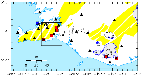
Figure 3:
Map of southwest part of Iceland showing the location
of the continuous GPS stations in the ISGPS network (red squares), the
continuous GPS station REYK (blue square) and SIL seismic stations
(black triangles). The black boxes show locations of the detailed maps
(Figures 1 and 2).
The yellow areas are volcanic fissure
swarms, and the calderas are shown with black lines with tick marks.
Thin black lines denote mapped
faults (Einarsson and Sćmundsson,1987; Erlendsson,1996).