Much more work was carried out in data collection and data evaluation than anticipated when the workprogramme was prepared.
This was partly due to general extensions of the applied monitoring systems, but partly due to very high seismic and deformation activity in the Hengill-Ölfus area in SW Iceland (Figure 1). Enormously significant data were collected in this area which contain earthquake premonitory activity and short-term precursors to earthquakes, especially in June 1998 and in November 1998. The data collection and evaluations carried out in relation to this activity are of basic significance in understanding crustal processes leading to earthquakes, for modelling motions in an earthquake and for modelling the observed large-scale stress modifications that were caused by the two earthquakes. [3]
The extension of the SIL seismological acquisition and evaluation system, the SIL system, has continued. [10,52] The SIL system is a front line system with high level network facilities for detecting small signals and evaluating wave forms.
Quite often during high earthquake activity the incoming data of small earthquakes is so high in the SIL system that the communication system and the computers have problems to cope with the data stream, and jams were created, which sometimes could delay the data, so the system evaluation was delayed. This could even lead to loss of data. As it is very significant to gather earthquake data down to the smallest earthquakes, that provide information about crustal conditions, it was necessary to design and implement more effective procedures for doing this. For this purpose a new compresssion algorithm was developed for the system, i.e. the bit compression. This algorithm compresses the data very effectively at the site stations and the compressed data go directly into the evaluation procedures at the SIL center, much faster than the earlier procedures. A new format for saving the digital earthquake waveform data will be described shortly in following:
The output of the seismometer digitizer is a series of integer values. The sample-to-sample variation is usually much less than the maximum values, which for most of SIL stations are between +/-3276800. In the AH format which was used by the SIL software, each value is stored in 32 bits.
A reduction in size of the data files of approximately a factor of 5 is achieved by storing the sample-to-sample variation in packed, variable size integers.
The access to data is thus much faster than to data that is compressed using general purpose compression programs such as gzip or compress and the files are typically 2-3 times smaller.
This new bit-compress format (bc) was incorporated into the data aqusition in the SIL system during the autumn of 1998. The software on each station writes in ascii files in format that is called the SIL format. The program bc-tool can convert these files to the bc format and back. All information in the headers is preserved.
The bc files are then transfered to the SIL center (currently using uucp). All files from each day are kept together, with a directory for each station. An index file that contains a list af all waveforms for each day is maintained.
The index files are stored on binary form, and are sorted by the programs that read them. A major performance bottleneck in previous version resulted from sorting index files on ascii form, each time that waveform data arrived.
The new software is able to keep up with much larger levels of earthquake activity than previous software. Because the routines that read and uncompress the data are very fast and files are small, performance of all programs that use the data has been improved.
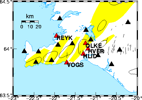
A build-up of continuous GPS monitoring at 4 sites in SW Iceland is a significant step forward for the PRENLAB-2 project data collection. It is significant for the watching the presently high seismic rate and deformation rate in the area. Four stations were installed in the Hengill-Ölfus area as shown in Figure 2.
The data processing is done at IMOR.DG,
using the Bernese
version 4.0 software from University of Berne. We are using data
from the IGS station Reykjavík (REYK) as a reference
station. The data from the network and results will
be made available via the internet. The URL is
http://www.vedur.is/ja/gps.html.
A station for continuous monitoring of conductivity at depth in the crust by MT method was installed at the SIL station HAU, at the eastern end of the South Iceland seismic zone, and the data acquistion is merged with the SIL data acquisition. Changes of conductivity in the crust may provide significant information about conditions in the seismic zones.