


Next: Task 3: Methods for
Up: Subproject 2: Development of
Previous: Task 1: Methods for
Start: July 1996 (month 5)
End: October 1997 (month 20)
Responsible partner: UUPP.DGEO
Cooperative partner: IMOR.DG
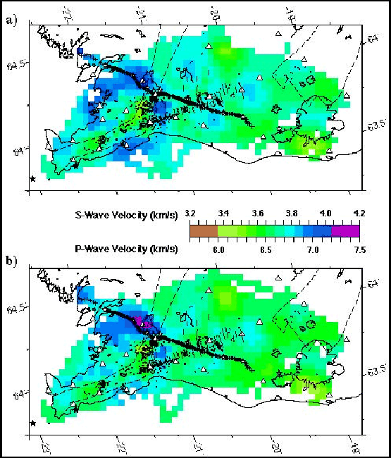
Selected from the SIL seismic database, 6200 local earthquakes have been
used in a tomography study of the 3-D P- and S-wave velocities and
hypocentral locations beneath SW-Iceland [86,].
The study region is a 224 112 km2 rectangular
area. Major tectonic features within the study region include the SISZ, the Hengill volcanic system, the Western
volcanic zone (WVZ), and the Reykjanes volcanic zone (RVZ). The velocity
model block size used was
112 km2 rectangular
area. Major tectonic features within the study region include the SISZ, the Hengill volcanic system, the Western
volcanic zone (WVZ), and the Reykjanes volcanic zone (RVZ). The velocity
model block size used was  km horizontally and 1 km vertically,
resulting in detailed velocity models. The resulting velocity
structures are well constrained down to depths of 10-12 km.
Figure 5
shows a horizontal slice through the models between the depths of 6 and 7
km. The main results of the interpretation are:
km horizontally and 1 km vertically,
resulting in detailed velocity models. The resulting velocity
structures are well constrained down to depths of 10-12 km.
Figure 5
shows a horizontal slice through the models between the depths of 6 and 7
km. The main results of the interpretation are:
- A large low-velocity anomaly is found at depths between 4 to 12 km
beneath the Hengill volcanic fissure system. Both P- and S-wave velocities
are low, but the reduction in the P-wave velocity is larger than in the
S-wave velocity, suggesting that the anomaly is not caused by large
portions of partial melt. The observed anomaly is interpreted as a heavily
fractured volcanic fissure system and the low velocities are caused by
supercritical magmatic fluids (CO2 and H2O) which are migrating in the
fracture system. Theoretical calculations of the elastic moduli for a
porous medium, using both magma saturated pores and supercritical water,
support this interpretation.
- The SISZ has normal velocities with a tendency towards lower than
normal Vp/Vs ratios (1.75). A slight increase in the depth to the lower
crust (P-wave velocities of 6.5 km/s) is observed along the SISZ from west
to east, from less than 4 km to below 5 km.
- In the depth range 5-7 km, lower than normal P- and S-wave
velocities are observed in the center of the RVZ. A tendency to increased
Vp/Vs ratios is observed at 4-8 km depth beneath the Krísuvík volcanic
system, which might be caused by elevated temperatures.
- The depth to the base of the brittle crust in the study area,
defined as the depth above which 90% of the earthquakes occur, varies from
about 5 km in young (0-0.7 My) crust near the RVZ and WVZ to about 12 km
near the eastern end of the SISZ. This corresponds to the estimated depths
of the
 C isotherm.
- Clusters of earthquakes deeper than the base of the brittle layer
occur beneath the Hengill and Eyjafjallajökull volcanoes. These earthquake
sequences may be associated with periods of unusually high
strain rate in the roots of the volcanic systems.
Figure 5:
Horizontal slices through the models at 6-7 km for a)
the S-wave velocities and b) the P-wave velocities. Model blocks
without any ray travelling through them are white. Earthquakes
occurring within the layer are shown. The thin stippled lines outline
the volcanic zones.
 |
Next: Task 3: Methods for
Up: Subproject 2: Development of
Previous: Task 1: Methods for
Gunnar Gudmundsson
1999-03-17