Physics Department (formerly Department of Geophysics) |
 |
| Department - Earthquakes- GPS -Tremor -Strain- Related links - Staff & email - Coworkers and reports- Icelandic - webmaster@vedur.is PREPARED |
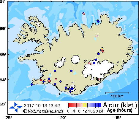
| Note! These are first results of the automatic location
system. The earthquakes have not been interactively analyzed. Locations of earthquakes in Iceland in the last 48 hours are shown as circles. The image is refreshed every 2 minutes. The colors of the circles show the time since the earthquakes occured (the numbers below the color palette represent hours). The latest earthquakes are shown in red and the dark blue ones occurred over 24 hours ago. The earthquakes stay blue until 48 hours have elapsed since their occurrence, then they disappear. Earthquakes bigger than M3 (on the Richter scale) are represented with green stars that turn yellow after 24 hours. For regional maps click the desired region in the green banner or the map. EWIS: early warning and information system (Apologies for the Icelandic text, an English version will follow soon.) Earthquakes for Google Earth |
|