

Next: Vertical velocities
Up: Plates and plate velocities
Previous: Velocity estimation after removing
To exclude the effects of the Hekla 2000 eruption and coseismic displacements at HLID
due to the June 2000 SISZ earthquake sequence a third set of velocities
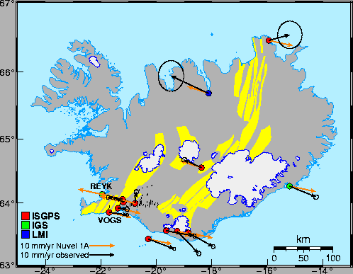
is calculated (Table 8, Figures 26 and 27)
using data only after August 1, 2000, until December 31, 2001. It is not
necessary to correct for any offsets, except for an offset due to
a instrumental change at HOFN in September 2001 (Table 2).
The results are expected to be the same as in Tables 6
and 7 for stations that were installed after August 1, 2000
(AKUR, KIDJ, RHOF and SKRO).
The velocities obtained in this section
can be interpreted as interseismic velocities at the stations.
Most stations are moving at velocities similar to the NUVEL-1A
plate motion model, except for the stations SOHO and HVOL near Mřrdalsj÷kull
and in the Hengill area (Figure 27).
The velocities are similar to the ones obtained in the previous
section (Table 7), except for SOHO, HVOL
and HLID.
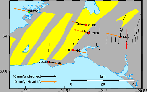
The stations HLID, HVER, OLKE and KIDJ are within
the plate boundary deformation zone moving at intermediate velocities.
Station VOGS is moving at almost the NUVEL-1A rate, HLID is
on the Eurasian side of the plate boundary, and HVER
is on the North-American side of the plate boundary. OLKE is
moving at nearly the NUVEL-1A rate for the North-American plate.
There are only 15 km between HLID and HVER and the present
location of the plate boundary is confined between
the stations.
KIDJ is moving almost due north. KIDJ is within the SISZ,
approximately 5 km west of the Hestfjall fault which ruptured on June 21, 2000
(Figure 27).
Thus postseismic movements at the right lateral Hestfjall fault might be affecting
the movement of KIDJ.
Table 8:
Calculated velocities of the stations in east, north and up, relative to REYK,
using data from August 1, 2000, as of December 31, 2001. See Table 6 for
explanation of the columns.
| |
|
Velocities [mm/yr] |
Uncertainties [mm/yr] |
WSTD [mm] |
Chi squared |
| Station |
N |
Ve |
Vn |
Vu |
dVe |
dVn |
dVu |
e |
n |
u |
 |
 |
 |
| AKUR |
102 |
-5.5 |
4.9 |
3.0 |
2.5 |
3.1 |
12.8 |
1.3 |
1.7 |
7.0 |
1.7 |
1.2 |
1.8 |
| HLID |
252 |
13.3 |
-2.6 |
5.7 |
0.4 |
0.5 |
1.8 |
1.1 |
1.3 |
4.9 |
1.4 |
0.8 |
0.9 |
| HOFN |
447 |
20.2 |
-6.5 |
7.1 |
0.5 |
0.4 |
1.5 |
2.2 |
1.8 |
6.4 |
2.6 |
1.7 |
1.5 |
| HVER |
487 |
6.4 |
-0.7 |
0.8 |
0.3 |
0.3 |
1.1 |
1.3 |
1.4 |
5.0 |
2.2 |
1.0 |
0.9 |
| HVOL |
453 |
19.6 |
-7.7 |
6.0 |
0.3 |
0.4 |
1.4 |
1.4 |
1.8 |
6.3 |
2.0 |
1.6 |
1.3 |
| KIDJ |
330 |
10.2 |
2.5 |
5.4 |
0.4 |
0.5 |
2.0 |
1.0 |
1.1 |
4.8 |
1.3 |
0.7 |
0.9 |
| OLKE |
464 |
3.7 |
-1.3 |
5.5 |
0.3 |
0.4 |
1.1 |
1.4 |
1.7 |
4.6 |
2.5 |
1.7 |
0.9 |
| RHOF |
128 |
18.0 |
0.1 |
-6.2 |
2.5 |
2.8 |
10.5 |
1.6 |
1.8 |
7.1 |
1.8 |
1.1 |
1.6 |
| SKRO |
416 |
2.7 |
1.1 |
16.1 |
0.5 |
0.5 |
2.4 |
1.8 |
1.6 |
8.4 |
3.1 |
1.4 |
2.7 |
| SOHO |
469 |
18.3 |
-11.2 |
6.0 |
0.4 |
0.5 |
1.5 |
1.6 |
2.0 |
6.2 |
2.7 |
1.9 |
1.3 |
| THEY |
462 |
21.0 |
-4.3 |
2.3 |
0.3 |
0.4 |
1.5 |
1.4 |
1.8 |
6.3 |
2.2 |
1.6 |
1.5 |
| VMEY |
493 |
20.0 |
-6.1 |
3.9 |
0.3 |
0.3 |
1.2 |
1.3 |
1.3 |
5.1 |
1.8 |
0.9 |
0.9 |
| VOGS |
487 |
16.9 |
-3.1 |
5.5 |
0.3 |
0.3 |
1.0 |
1.1 |
1.3 |
4.6 |
1.6 |
0.8 |
0.8 |
|
Figure 26:
Velocities for the permanent GPS stations, as in Table 8,
assuming REYK is moving at velocity
9.6 mm/yr west and 2.1 mm/yr north (black arrows) compared to
the NUVEL-1A plate motion model velocities (orange arrows). The velocities are based on data
spanning the period August 2000 to January 2002. Confidence limits are
at the 2 level.
 |
Figure 27:
As in Figure 26 for the Hengill area. Red line shows
the location of the fault that ruptured in the June 21, 2000, earthquake
according to [┴rnadˇttir et al. (2001)].
 |


Next: Vertical velocities
Up: Plates and plate velocities
Previous: Velocity estimation after removing
Halldor Geirsson
2003-03-21

