


Next: The June 2000 earthquake
Up: Results
Previous: Eyjafjallajökull and Katla volcanoes
The volcano Hekla is located at the intersection of the
Eastern volcanic zone and the SISZ (Figure 34).
Its volcanic history during historic times is characterized by one or two
vigorous eruptions per century. The activity pattern changed after the 1947-1948
eruption
[Þórarinsson (1967)]
and smaller eruptions ocurred in 1970,
1980-1981, 1991 and 2000. Deformation measurements in the vicinity of Hekla
started in 1968 with tiltmeter observations
[Tryggvason (1994)].
The tiltmeter observations show a pattern of slow inflation during periods
of repose and rapid deflation during eruptions
[Tryggvason (1994)].
Deformation measurements have been interpreted as pressure changes in a magma source
at 5 to 9 km depth below Hekla
[Tryggvason (1994)],
[Sigmundsson et al. (1992)],
[Linde et al. (1993)],
[Ágústsson et al. (2000)].
Seismic activity in Hekla is generally very low
[Soosalu and Einarsson (1997)] and no long-term
precursory seismicity is observed before eruptions. Short-term precursors manifested in small
earthquake swarms and changes at volumetric strain stations are observed
around one hour before the eruption breaks to the surface.
The latest eruption started at 18:19 on February 26, and lasted until
March 8. The eruption started with activity on a 4 km long fissure along the
Figure 32:
Time series of the north components of GPS
stations SOHO and HVOL assuming REYK is fixed. The start and end
of the Hekla 2000 eruption are marked with vertical lines. Error bars
are omitted for clarity.
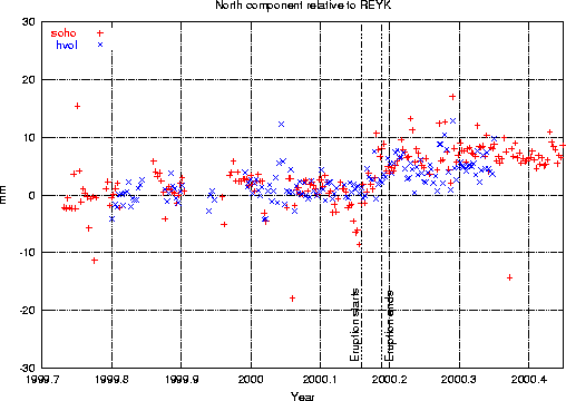 |
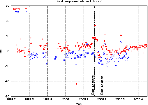
Figure 33:
Time series of the east components of GPS
stations SOHO and HVOL assuming REYK is fixed. The start and end
of the Hekla 2000 eruption are marked with vertical lines. Error bars
are omitted for clarity.
 |
ridge of the volcano, but confined soon to a few eruptive vents.
The closest continuous GPS station recording at the time of the eruption was at
Sólheimaheiði (SOHO), at approximately 53 km distance SE of the summit of Hekla.
Despite the distance a small deformation signal was seen at the stations SOHO and
HVOL (Figures 12 and 17).
Figures 32 and 33 show a blow-up of the time
series of the horizontal components
of SOHO and HVOL around the time of the eruption. The signal seems to be more
prominent at SOHO and points towards Hekla. Kristján Ágústsson kindly provided
the predicted displacements at the operational ISGPS stations
[Ágústsson et al. (2000)].
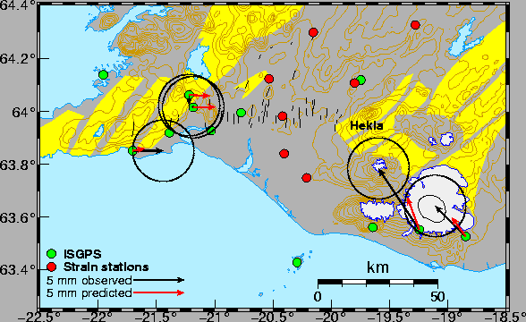
His model of the
deformation is derived from measurements at continuously operating volumetric
strain stations (Figure 34). The closest volumetric strain station
is 15 km from Hekla. His model is similar to the one described in
[Linde et al. (1993)], consisting of a deflating pressure source at
7.7 km depth and an expanding dike with strike 65 .
.
Figure 34:
Comparison of co-eruptive signals at the ISGPS stations that were
recording at the time of the Hekla 2000 eruption. ISGPS stations
are marked with green circles and volumetric strain stations are marked
with red circles. Legend Hekla on the map is just S of Hekla
volcano. The observed displacements are shown with black arrows. Red
arrows note the predicted displacements calculated from a model
of the eruption based on data from the volumetric strain stations
(K. Ágústsson, personal communication 2002).
 |
In the first phase of the eruption, before
the eruption breaks through the surface, the volumetric
strain signal is governed by compression from a rapidly forming dike extending
from the magma reservoir to the suface. In the second phase the eruption has
reached the surface. The dike is still growing and pressure is decreasing in
the magma reservoir. In the third phase the dike is fully grown and the
volumetric strain signal shows expansion due to pressure decrease in the
magma chamber. The predicted displacements for the sum of all three phases are
1.2 mm towards west and 3.2 mm north for SOHO, and 1.4 mm west and 1.9 mm north
for HVOL. The displacements, estimated from the time series,
at SOHO (4  3 mm W and 6
3 mm N)
and HVOL (3
3 mm W and 3
3 mm N) agree with the predicted
displacements regarding size and direction (Figure 34) although
the signal at SOHO seems to be slightly larger than is predicted.
3 mm W and 6
3 mm N)
and HVOL (3
3 mm W and 3
3 mm N) agree with the predicted
displacements regarding size and direction (Figure 34) although
the signal at SOHO seems to be slightly larger than is predicted.
A new ISGPS station at Ísakot (ISAK), 15 km NW of Hekla, was installed in January 2002
over an existing benchmark that has been included in network measurements since 1986 (Section 2).
During the Hekla 1991 eruption ISAK was observed to move 4.4 cm towards Hekla
[Sigmundsson et al. (1992)].
Predicted displacements at ISAK for the Hekla 2000 eruption are approximately 4 cm
towards the volcano.
Next: The June 2000 earthquake
Up: Results
Previous: Eyjafjallajökull and Katla volcanoes
Halldor Geirsson
2003-03-21