In June 1994 an earthquake swarm lasting for nearly a month occurred below the active volcano Eyjafjallajökull in South Iceland. Eyjafjallajökull is covered by an ice cap and erupted last in 1821-1823. Another sharp increase in the seismic activity beneath the mountain started in October 1998 and lasted until January 2001 with peak activity during July to September 1999. Observed thrust faulting mechanisms, GPS network measurements and tilt measurements support that the seismic swarms were due to shallow intrusions into the southern part of the mountain [Dahm and Brandsdóttir (1997)], [Sturkell et al. (2002b)]. The timing of the intrusive activity has been constrained with geodetic observations to occur within the time period between July 1999 and May 2000 [Sturkell et al. (2002b)].
The permanent GPS station THEY, installed in May 2000, is within 6 km from the modelled intrusion centers from 1994 and 1999 [Sturkell et al. (2002b)] and is thus well suited to monitor future evolution of local intrusion activity beneath the southern flanks of Eyjafjallajökull. No signs of postintrusive movements have been observed at THEY.
The nearest continuous station that was recording in 1999 (SOHO) is within 20 km east of the intrusion center. The station was installed in late September 1999 and shows no conclusive signs of activity related to Eyjafjallajökull. The intrusive activity could have been over already in late September 1999. Sturkell et al. (2002b) model the deformation field observed in geodetic data covering the 1999 event as coming from a shallow pressure source (3.5 km depth). According to their model the total displacement at SOHO during the whole intrusive event should be approximately 12 mm east (E. Sturkell, personal communication 2002).
The average velocity of SOHO relative to REYK during
September 24, 1999, to February 20, 2000, (87 data points) is
7 mm/yr ![]() 3 mm/yr east and 3 mm/yr
3 mm/yr east and 3 mm/yr ![]() 4 mm/yr north (2
4 mm/yr north (2![]() uncertainties).
This velocity is considerably lower than the NUVEL-1A velocity relative to REYK
(19 mm/yr east and -4 mm/yr north).
If the effects of the intrusion were discernible at SOHO we would expect
velocities larger than the NUVEL-1A.
Assuming it is possible to detect movements of 6 mm
we can conclude that at least half of the deformation due to the intrusion
in Eyjafjallajökull had occurred before the installation of the station (September 24, 1999).
uncertainties).
This velocity is considerably lower than the NUVEL-1A velocity relative to REYK
(19 mm/yr east and -4 mm/yr north).
If the effects of the intrusion were discernible at SOHO we would expect
velocities larger than the NUVEL-1A.
Assuming it is possible to detect movements of 6 mm
we can conclude that at least half of the deformation due to the intrusion
in Eyjafjallajökull had occurred before the installation of the station (September 24, 1999).
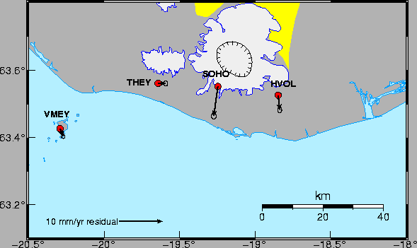
Katla volcano is an off-rift volcano beneath Mýrdalsjökull glacier in South Iceland. The ice-filled caldera, outlined in Figure 31, is 10x13 km in diameter and approximately 700 m deep [Björnsson et al. (2000)]. Katla is known for great eruptions with devastating jökulhlaups and has erupted 20 times in the last 11 centuries [Larsen (2000)]. The last great eruption was in 1918, but possibly two small eruptions that did not penetrate the glacier occurred in 1955 [Tryggvason (1960)] and 1999 [Einarsson and Brandsdóttir (2000)], [Vogfjörð (2002)]. The Mýrdalsjökull area has shown persistent high seismic activity for more than four decades. There is a strong seasonal trend in the activity with most of the earthquakes occurring in the autumn [Einarsson and Brandsdóttir (2000)]. Crustal deformation measurements using precise levelling and network GPS survey data in the Mýrdalsjökull area during 1967 to present do not show significant deformation [Tryggvason (2000)], [Sturkell (2002a)]. On July 18, 1999 a small jökulhlaup occurred in Jökulsá á Sólheimasandi [Sigurðsson et al. (2000)] accompanied with seismic tremors. Due to this event and the fact that Katla is overdue for a large eruption, two permanent GPS stations were installed at Sólheimaheiði (SOHO) and Láguhvolar (HVOL) (Figure 31) in the autumn of 1999.
SOHO is located approximately 10 km from the center of the caldera.
Models of potential deformation fields by [Ágústsson (2000)] suggest that
the station is very sensitive to pressure changes in Katla. From Figure
26 there seems to be an enhanced southward motion
at stations SOHO and HVOL compared to the NUVEL-1A model and surrounding
stations. The residual velocities, obtained by subtracting
the full NUVEL-1A rate from the rates in Table 8,
of SOHO, HVOL, VMEY and THEY are shown in Figure 31.
SOHO is moving outwards from the Katla caldera at 0.9 ![]() 0.4 mm/yr west and 6.9
0.4 mm/yr west and 6.9 ![]() 0.5 mm/yr south
and HVOL is moving at 0.4
0.5 mm/yr south
and HVOL is moving at 0.4 ![]() 0.3 mm/yr east and 3.5
0.3 mm/yr east and 3.5 ![]() 0.4 mm/yr
relative to Eurasia during the period August 2000 to December 2001.
0.4 mm/yr
relative to Eurasia during the period August 2000 to December 2001.
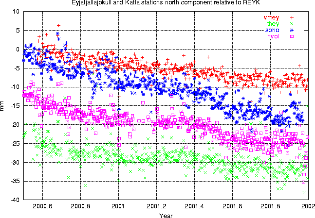
Comparing time series from after the June 2000 SISZ earthquakes at stations SOHO, HVOL, THEY and VMEY reveals a more detailed picture of the movements. From Figure 30 we see that SOHO and perhaps HVOL are moving at a higher rate southward than the neighbouring stations VMEY and THEY. From the figure we see slightly enhanced southward motion of the stations just after the June 2000 earthquakes. We also see enhanced southward movement at SOHO and HVOL during July to August 2001. The displacements at SOHO and HVOL during this short period are around 5 mm towards south. There are no significant anomalous movements observed in the east and vertical components of the time series during the period July to August 2001. It is interesting to note that the southward movements in July to August 2001 took place when there was a low in the annual seismic activity in Mýrdalsjökull.
 |
GPS network measurements were made in the area in July 2000 and in the beginning of June 2001. Although the latter measurements were made prior to the enhanced southward motion in July and August 2001, the horizontal displacements found by comparing the network measurements indicate a slight outward movement from the Katla caldera [Sturkell et al. (2002a)]. The results from the ISGPS stations along with the network campaign results suggest inflation in the Katla volcano. Alternatively, the data could be interpreted as a response to changing load on the glacier. Tryggvason (1973) reports observation of annual changes in tilt using data from optical levelling dry-tilt stations located close to the glacier edge. The tilt measurements are interpreted as a signal due to annual loading of the Mýrdalsjökull glacier. Periodic variations observed in the time series for HVOL, SOHO and THEY (Figures 12, 17 and 18) can be interpreted as a sign of annual glacial loading. If periodic variations in the vertical component are indeed a result of glacial loading, they show us that these are smooth changes and cannot explain the enhanced southward movement observed during the period July to August 2001.
 |