 |
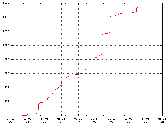
In July 1994, a period of unusually intense seismic activity started in the Hengill area [Rögnvaldsson et al. (1998a)]. Figure 29 summarizes the seismic activity from 1993 to 2002 as the cumulative number of earthquakes with magnitudes greater than 2 in the Hengill area. Most of the earthquakes had magnitudes below 4, but still the total number of recorded earthquakes in the area since 1994 until 2002 is over 100 thousand. Figure 29 shows the abrupt onset of the seismicity in 1994 and how the seismic activity culminated in two separate seismic swarms in June and November 1998 with two magnitude 5 earthquakes [Ágústsson (1998)], [Rögnvaldsson et al. (1998b)]. The seismicity in the Hengill area was low from November 1998 until the SISZ June 2000 earthquakes, when a moderate swarm was triggered by the large earthquakes (Figure 29). After June 2000 the seismicity dropped back to its background levels as before 1994.
Levelling, GPS network measurements and InSAR studies,
all indicate uplift in the area in the period 1994 to 1998 with maximum uplift located between
the Hrómundartindur and Grensdalur systems
[Sigmundsson et al. (1997)],
[Hreinsdóttir (1999)],
[Þorbergsson and Vigfússon (1998)],
[Feigl et al. (2000)].
The uplift is interpreted as the result of a pressure increase in a magma source at
7 ![]() 1 km depth. The inflation induces stresses that
exceed the Coulomb failure criteria and thus triggers the earthquakes
[Feigl et al. (2000)].
Feigl et al. (2000)
find from InSAR
data a fairly constant uplift rate of 1.9
1 km depth. The inflation induces stresses that
exceed the Coulomb failure criteria and thus triggers the earthquakes
[Feigl et al. (2000)].
Feigl et al. (2000)
find from InSAR
data a fairly constant uplift rate of 1.9 ![]() 0.2 cm/yr which should be easily detected
by the permanently recording GPS station at Hveragerði (HVER) and Ölkelduháls (OLKE)
since they are within 4 km from
the center of the uplift area (HVER and OLKE are 2 km SE and 4 km N of the inferred center,
respectively).
Network GPS measurements of displacements
of a station close to HVER (RKOT) do not indicate significant
uplift in the period November 1998 to March 1999, relative to REYK
[Hreinsdóttir (1999)].
However, a significant uplift (3 cm) was observed between June 1998
and June 1999 at a station near OLKE (7393), relative
to a station approximately 10 km NW of OLKE
[Þorbergsson (1999)].
0.2 cm/yr which should be easily detected
by the permanently recording GPS station at Hveragerði (HVER) and Ölkelduháls (OLKE)
since they are within 4 km from
the center of the uplift area (HVER and OLKE are 2 km SE and 4 km N of the inferred center,
respectively).
Network GPS measurements of displacements
of a station close to HVER (RKOT) do not indicate significant
uplift in the period November 1998 to March 1999, relative to REYK
[Hreinsdóttir (1999)].
However, a significant uplift (3 cm) was observed between June 1998
and June 1999 at a station near OLKE (7393), relative
to a station approximately 10 km NW of OLKE
[Þorbergsson (1999)].
OLKE was installed in May 1999 and has not shown any significant signs of uplift
since it was installed (Figure 14). The velocities of OLKE
relative to REYK using data from
the start of measurements until December 1999 are 7 ![]() 2 mm/yr east,
-3
2 mm/yr east,
-3 ![]() 2 mm/yr north and 15
2 mm/yr north and 15 ![]() 8 mm/yr up.
HVER was installed in late March 1999. In the time series for HVER relative to
REYK (Figure 11) there is a vague signal of southward movement
and uplift.
The velocities of HVER relative to REYK, using data from
the start of measurements until December 1999, are 10
8 mm/yr up.
HVER was installed in late March 1999. In the time series for HVER relative to
REYK (Figure 11) there is a vague signal of southward movement
and uplift.
The velocities of HVER relative to REYK, using data from
the start of measurements until December 1999, are 10 ![]() 2 mm/yr east,
-7
2 mm/yr east,
-7 ![]() 2 mm/yr north and 21
2 mm/yr north and 21 ![]() 6 mm/yr up. These velocities
indicate the presence of intrusive activity in the Hengill
area until the fall of 1999. It is likely that the network measurements
at RKOT between November 1998 and March 1999
[Hreinsdóttir (1999)]
were unable
to detect uplift at station because the expected uplift in the period,
less than 10 mm assuming a rate of 20 mm/yr, is of the same order
as the uncertainties in network GPS measurements.
6 mm/yr up. These velocities
indicate the presence of intrusive activity in the Hengill
area until the fall of 1999. It is likely that the network measurements
at RKOT between November 1998 and March 1999
[Hreinsdóttir (1999)]
were unable
to detect uplift at station because the expected uplift in the period,
less than 10 mm assuming a rate of 20 mm/yr, is of the same order
as the uncertainties in network GPS measurements.